The earthquake risk map of Europe

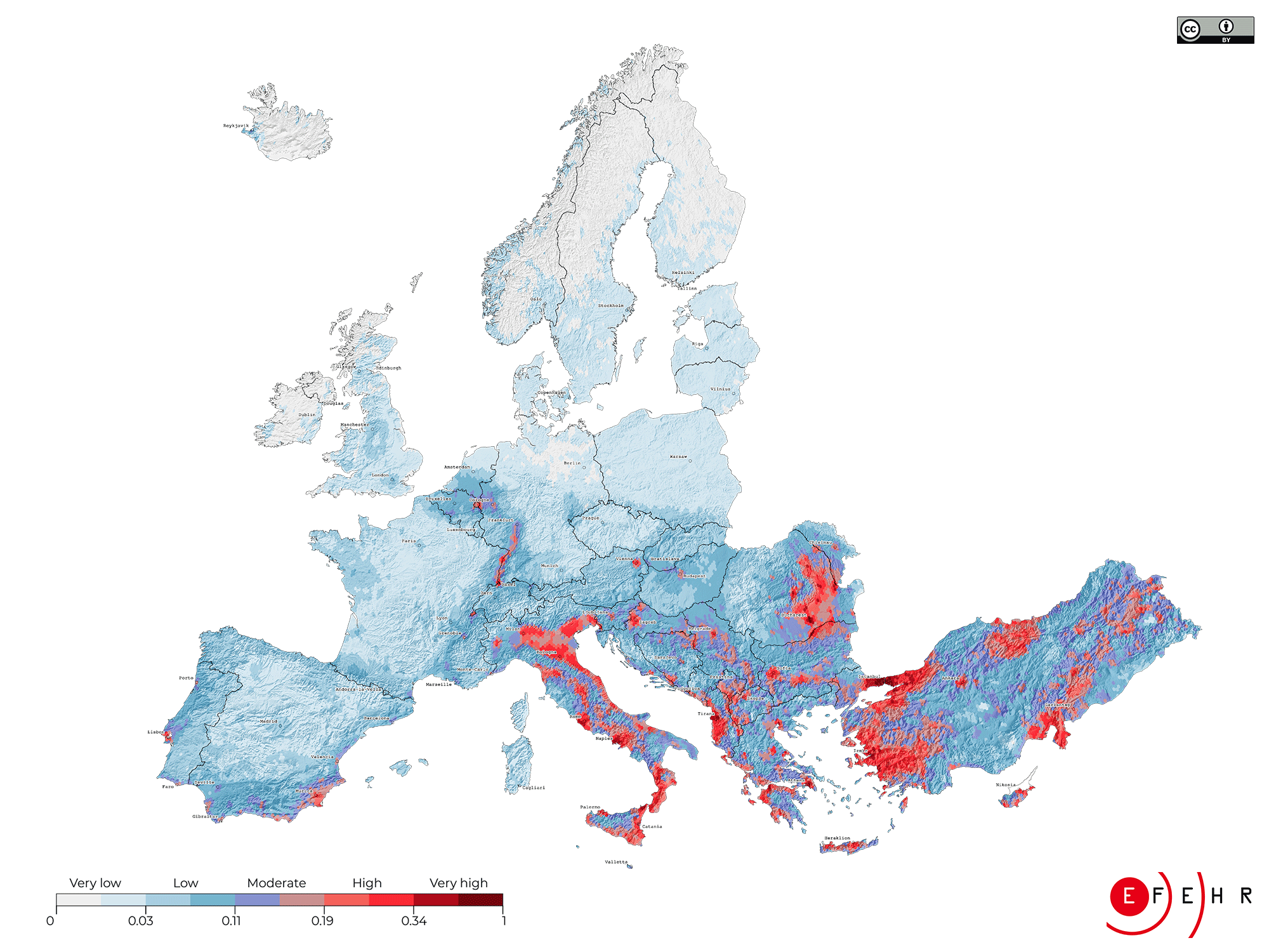
The map of European earthquake risk illustrates the relative distribution of expected risk across Europe through a composite index. This index is produced by combining the average annual economic loss and the average annual loss of life calculated from Europe's first openly available seismic risk model of its type, normalised by the GDP per capita to account for the varying levels of resilience across Europe.
Seismic risk index
How to read the map
Low risk areas are coloured from white to light blue, moderate risk areas from blue to red and high risk areas appear in dark red.
The "very high" risk index areas could have an average annual economic loss of up to 65 Million Euros and could reach over 30 fatalities a year, whereas the losses in a "moderate" risk index area could instead be up to 25 Million Euros, with up to 2 fatalities per year.
What does the map tell us about different regions?
The main drivers of the earthquake risk are older buildings, high earthquake hazard, and urban areas. The highest earthquake risk and thus the most severe consequences of earthquakes are expected in urban areas located in regions with a comparably high earthquake hazard.
Examples of places with high earthquake risk are in urban areas, such as the cities of Istanbul and Izmir in Turkey, Catania and Naples in Italy, Bucharest in Romania, and Athens in Greece, many of which have a history of damaging earthquakes. In fact, these four countries alone experience almost 80% of the modelled average annual economic loss of 7 billion Euros due to earthquakes in Europe. However, also cities like Zagreb (Croatia), Tirana (Albania), Sofia (Bulgaria), Lisbon (Portugal), Brussels (Belgium), and Basel (Switzerland) have an above-average level of earthquake risk compared to less exposed cities, such as Berlin (Germany), London (UK), or Paris (France).
Regions in Europe with a lower population density, such as the Nordic countries of Finland, Norway and Sweden, and a low to moderate earthquake hazard, on the other hand, have a lower earthquake risk relative to other areas in Europe. Iceland is known for its high level of earthquake activity. However, due to its low population and building construction characteristics, the earthquake risk is limited compared to other European regions, except for the capital Reykjavik and the surrounding towns.


